

![]()

![]()
Types of surveys we perform include, but are not limited to:
Field Surveys
Boundary Survey, As-Built Survey, ALTA ACSM Land Title Survey, GLO Section Line Retracement Survey, Geodetic Horizontal and Vertical Control Networks, GPS Survey, Aerial Photogammetry Control, Construction Layout, Mean High Water Survey, Ordinary High Water Survey, Right of Way Survey, Design Survey, Topographic and DTM Survey, Bridge-Channel Survey, Drainage Survey, Hydrographic Survey, Quantity Borrow Pit and Land Fill Survey and Hazardous Waste Site Surveys.
Survey Mapping
Boundary and As Built Maps, Base Maps and Design Plan Sheet Maps, Topographic maps, Subdivision Record Plats and Right of Way Maps. Produce maps utilizing Autodesk Civil Series 2004, Autodesk Land Desktop 3 with Civil Series 3, AutoCAD R14 with Softdesk 8, CAiCE Visual Transportation 10.0.1 and Microstation. Utilize many additional CADD drafting softwares.
Automated Surveying
Utilizes the most up-to-date electronic total stations and data collectors in the industry. With more than 10 years of data collection experience, we can collect raw data and produce electronic files in almost any format currently used. We employ the FDOT’s EFB data collection software, CAiCE processing software, TDS data collection software and COGO software as well as Civil Series 2004 processing and design software. Each system has proved itself invaluable in the various applications of field data collection, employing automated drawing and DTM production. Between the two, data can be exported into almost any CADD format.
Design And Route Surveying
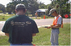
One of our main services, design and route surveying for roadway and utility design, has been a major part of our overall survey mission. Our work, for both the public and private sectors, ranges from new and existing roadways, water, sewer and utility installation, extension and rehabilitation to subdivisions, commercial sites, correctional facilities and waste water treatment plants.
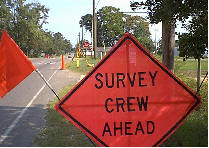
Construction Surveying
Being a full-service surveying firm, we provide construction layout and staking for most of our commercial, municipal and private roadway, utility and site design projects. We also perform all types of construction staking for road and building contractors.
Boundary Surveys
Boundary surveys (of all types) are another primary service of Snelgrove Surveying & Mapping, Inc. With three Professional Surveyors and Mappers with more than 80 years of combined experience, no boundary line problem is too tough for us to tackle. GLO section line retracement, one of the most difficult aspects of boundary surveying, is our specialty. Working in 41 of the 67 separate counties throughout the state of Florida, has made us very knowledgeable of the different histories, local customs and procedures for various regions throughout the state. We routinely perform surveys from one-half acre to 8,500-acre tracts. This has greatly enhanced our ability to perform multiple section ties along state roads for FDOT right of way and maintenance map surveys.
GPS
Snelgrove Surveying & Mapping, Inc. has recently updated our committed to the field of GPS, in addition to three Ashtech, Locus single frequency receivers and three ProMark2 dual frequency receivers and the processing software with two professional surveyors proficient in their use, we have recently acquired a Leica Real Time Kinematic (RTK) base station and rover unit which allows us to take centimeter level accuracy measurement in real time mode. It allows us to capture and attribute data. This application also minimizes our use of manpower and providing significant savings to the end user and clients.
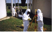
Hazardous Waste Site Surveys
Hazardous waste sites, in recent years, have increased dramatically. Topographic and boundary surveys on the state plane coordinate system and NAVD 88 vertical datum, are generally required by the state for remediation and litigation purposes. Since we currently have 10 survey personnel with 40 hours of HAZWOPER training, we can deploy to any site within 8 to 48 hours notice. We understand the complexity of working such a site and the necessity for quick response, careful planning and safety assurance.
Mean High Water Surveys
Tide studies and infrared aerial photogrammetry, as well as traditional survey methods, are used along Florida’s Gulf and Atlantic coasts and tidally influenced river systems. While meeting all of DEP’s field and office mapping survey procedures and specifications, boundary and ordinary high water surveys for private individuals, companies and the various water management districts, are accomplished.